Malta geological maps miss 50 metres of rock
 |
| A section of rock across the Maltese islands is unrecorded in the official geological map on which important decisions are based, fresh research suggests. |
?This section of rock, which has a maximum thickness of 50 metres, is there but is not officially recorded, and yet the Planning Authority and the former Malta Resources Authority have been taking decisions on quarries, excavations and tunnels based on outdated geological maps,? said geologist Peter Gatt.
Malta has five rock formations, three of which are of economic use and sub-divided into ?members?.
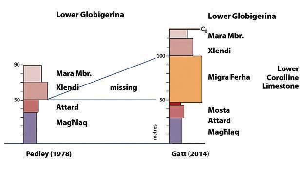
Dr Gatt has called the ?missing? section ?Mi?ra Fer?a Member?. It is not found in the official stratigraphy that is based on studies undertaken by British geologists, especially Martyn Pedley in 1978.
?The official map showing the geology of the Maltese islands was revised by the Oil Exploration Directorate in 1993, and yet this 50-metre section of rock forming part of the lower coralline limestone formation remained unrecorded,? he said.
Lower coralline limestone is the hard rock found in the bottom layer of Malta?s rock structure. The rock is important because it holds fresh water reserves and has economic value for the construction industry since it is used to make aggregate.
Dr Gatt has been researching lower coralline limestone for the past few years and presented some of his findings publicly last week during a conference on water re?sources organised by the Water Services Corporation and Mcast.
The thickness of lower coralline limestone recorded in current geological maps adds up to less than 90 metres, when actual outcrops of rock reach over 120 metres. The discrepancy is the Mi?ra Fer?a layer.
?In his analysis of the various strata forming part of the lower coralline limestone, Pedley did not record a 50-metre stretch of rock, which I have recorded during geological investigations around Malta and Gozo,? Dr Gatt explained.
His studies were conducted in some 20 localities, including Dwejra in Gozo, the Mosta quarry, Mi?ra Fer?a on Malta?s west coast, Wied ?nuber and Qala.
The ?missing? rock is made up of centimetre-sized spherical structures of calcareous red algae that lived 27 to 26 million years ago. These are distinct from fossils in the Xlendi and Attard members, immediately above and below it.
Dr Gatt also discovered a bed of phosphates (C0 bed) overlying the lower coralline limestone, previously unrecorded, which explains the high levels of fluoride found in groundwater extracted from the San ?wann and St Julian?s area.
A long-time proponent of the need for the country to have its own National Geological Service that would carry out geological surveys to understand better the onshore and offshore rock formations, Dr Gatt called on the new Environment and Resources Authority to take note of the new stratigraphy he published in 2014. The stratigraphy, ?Field Guide to the Geology of the Maltese Islands?, was published in European Association of Geoscientists and Engineers for a conference sponsored by Shell and Statoil.
The authority, which is also res?ponsible for protecting natural resources, should update the geological maps, he argues. ?At a time when we are speaking of constructing a tunnel to Gozo, building under?ground roads to ease traffic congestion and determining policies on water, the country needs updated geological maps,? he said.