![green epidote crystal val malenco valtellina italy green epidote crystal val malenco valtellina italy](https://www.mineralfossil.com/wp-content/gallery/macro/thumbs/thumbs_epidoto-sissone.jpg)
![vesuvianite val malenco valtellina italy vesuvianite val malenco valtellina italy](https://www.mineralfossil.com/wp-content/gallery/macro/thumbs/thumbs_vesuviana-val-lanterna-3.jpg)
![vesuvianite val malenco valtellina italy vesuvianite val malenco valtellina italy](https://www.mineralfossil.com/wp-content/gallery/macro/thumbs/thumbs_vesuviana-val-lanterna.jpg)
![geode calcedonio brasil (2).JPG geode calcedonio brasil (2).JPG](https://www.mineralfossil.com/wp-content/gallery/south-america/thumbs/thumbs_geode-calcedonio-brasil-2.jpg)
![geode calcedonio brasil.JPG geode calcedonio brasil.JPG](https://www.mineralfossil.com/wp-content/gallery/south-america/thumbs/thumbs_geode-calcedonio-brasil.jpg)
![magnetite brasil.JPG magnetite brasil.JPG](https://www.mineralfossil.com/wp-content/gallery/south-america/thumbs/thumbs_magnetite-brasil.jpg)
![quartz japanese geminate brasil.JPG quartz japanese geminate brasil.JPG](https://www.mineralfossil.com/wp-content/gallery/south-america/thumbs/thumbs_quartz-japanese-geminate-brasil.jpg)
![azurite morocco.JPG azurite morocco.JPG](https://www.mineralfossil.com/wp-content/gallery/africa/thumbs/thumbs_azurite-morocco-2.jpg)
![calcite morocco.JPG calcite morocco.JPG](https://www.mineralfossil.com/wp-content/gallery/africa/thumbs/thumbs_calcite-morocco.jpg)
![carollite.JPG carollite.JPG](https://www.mineralfossil.com/wp-content/gallery/africa/thumbs/thumbs_carollite.jpg)
![celestine madagascar.JPG celestine madagascar.JPG](https://www.mineralfossil.com/wp-content/gallery/africa/thumbs/thumbs_celestine-madagascar.jpg)
![cerussite barite morocco.JPG cerussite barite morocco.JPG](https://www.mineralfossil.com/wp-content/gallery/africa/thumbs/thumbs_cerussite-barite-morocco.jpg)
![malachite Democratic Republic of the Congo (formerly Zaire) Lukuni Mine in Katanga Province.JPG malachite Democratic Republic of the Congo (formerly Zaire) Lukuni Mine in Katanga Province.JPG](https://www.mineralfossil.com/wp-content/gallery/africa/thumbs/thumbs_malachite-democratic-republic-of-the-congo-formerly-zaire-lukuni-mine-in-katanga-province.jpg)
![vanadinite morocco.JPG vanadinite morocco.JPG](https://www.mineralfossil.com/wp-content/gallery/africa/thumbs/thumbs_vanadinite-morocco.jpg)
![almandine gilgit pakistan.JPG almandine gilgit pakistan.JPG](https://www.mineralfossil.com/wp-content/gallery/asia/thumbs/thumbs_almandine-gilgit-pakistan.jpg)
![fluorite china.JPG fluorite china.JPG](https://www.mineralfossil.com/wp-content/gallery/asia/thumbs/thumbs_fluorite-china.jpg)
![fluorite india.JPG fluorite india.JPG](https://www.mineralfossil.com/wp-content/gallery/asia/thumbs/thumbs_fluorite-india.jpg)
![hematite rose on quartz china.JPG hematite rose on quartz china.JPG](https://www.mineralfossil.com/wp-content/gallery/asia/thumbs/thumbs_hematite-rose-on-quartz-china.jpg)
![lapislazzuli afganistan.JPG lapislazzuli afganistan.JPG](https://www.mineralfossil.com/wp-content/gallery/asia/thumbs/thumbs_lapislazzuli-afganistan.jpg)
![quartz epidote china.JPG quartz epidote china.JPG](https://www.mineralfossil.com/wp-content/gallery/asia/thumbs/thumbs_quartz-epidote-china.jpg)
![topaz pakistan.JPG topaz pakistan.JPG](https://www.mineralfossil.com/wp-content/gallery/asia/thumbs/thumbs_topaz-pakistan.jpg)
![topaz quartz pakistan.JPG topaz quartz pakistan.JPG](https://www.mineralfossil.com/wp-content/gallery/asia/thumbs/thumbs_topaz-quartz-pakistan.jpg)
![tormaline pakistan.JPG tormaline pakistan.JPG](https://www.mineralfossil.com/wp-content/gallery/asia/thumbs/thumbs_tormaline-pakistan.jpg)
![zircone pakistan.JPG zircone pakistan.JPG](https://www.mineralfossil.com/wp-content/gallery/asia/thumbs/thumbs_zircone-pakistan.jpg)
![analcime sardegna,Italy.JPG analcime sardegna,Italy.JPG](https://www.mineralfossil.com/wp-content/gallery/europe/thumbs/thumbs_analcime-sardegnaitaly.jpg)
![andradite garnet isola d'elba,Italy.JPG andradite garnet isola d'elba,Italy.JPG](https://www.mineralfossil.com/wp-content/gallery/europe/thumbs/thumbs_andradite-garnet-isola-delbaitaly.jpg)
![aragonite spagna.JPG aragonite spagna.JPG](https://www.mineralfossil.com/wp-content/gallery/europe/thumbs/thumbs_aragonite-spain.jpg)
![calcite italy.JPG calcite italy.JPG](https://www.mineralfossil.com/wp-content/gallery/europe/thumbs/thumbs_calcite-italy.jpg)
![calcite valtellina,Italy (2).JPG calcite valtellina,Italy (2).JPG](https://www.mineralfossil.com/wp-content/gallery/europe/thumbs/thumbs_calcite-valtellinaitaly-2.jpg)
![calcite valtellina,Italy (4).JPG calcite valtellina,Italy (4).JPG](https://www.mineralfossil.com/wp-content/gallery/europe/thumbs/thumbs_calcite-valtellinaitaly-4.jpg)
![calcite valtellina,Italy.JPG calcite valtellina,Italy.JPG](https://www.mineralfossil.com/wp-content/gallery/europe/thumbs/thumbs_calcite-valtellinaitaly.jpg)
![epidote valmalenco,Italy.JPG epidote valmalenco,Italy.JPG](https://www.mineralfossil.com/wp-content/gallery/europe/thumbs/thumbs_epidote-valmalencoitaly.jpg)
![grossularia liguria,Italy.JPG grossularia liguria,Italy.JPG](https://www.mineralfossil.com/wp-content/gallery/europe/thumbs/thumbs_grossularia-liguriaitaly.jpg)
![hessonite adamello,Italy.JPG hessonite adamello,Italy.JPG](https://www.mineralfossil.com/wp-content/gallery/europe/thumbs/thumbs_hessonite-adamelloitaly.jpg)
![orthoclase quartz elba island,Italy.JPG orthoclase quartz elba island,Italy.JPG](https://www.mineralfossil.com/wp-content/gallery/europe/thumbs/thumbs_orthoclase-quartz-elba-islanditaly.jpg)
![pyromorphite sardegna,Italy.JPG pyromorphite sardegna,Italy.JPG](https://www.mineralfossil.com/wp-content/gallery/europe/thumbs/thumbs_pyromorphite-sardegnaitaly.jpg)
![quartz emilia romagna,Italy.JPG quartz emilia romagna,Italy.JPG](https://www.mineralfossil.com/wp-content/gallery/europe/thumbs/thumbs_quartz-emilia-romagnaitaly.jpg)
![quartz formazza,Italy.JPG quartz formazza,Italy.JPG](https://www.mineralfossil.com/wp-content/gallery/europe/thumbs/thumbs_quartz-formazzaitaly.jpg)
![quartz rodocrosite romania.JPG quartz rodocrosite romania.JPG](https://www.mineralfossil.com/wp-content/gallery/europe/thumbs/thumbs_quartz-rodocrosite-romania.jpg)
![apatite messico.JPG apatite messico.JPG](https://www.mineralfossil.com/wp-content/gallery/north-america/thumbs/thumbs_apatite-messico.jpg)
![]() |
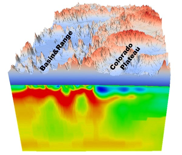
Geodynamic modelling relies on knowing the ‘viscosity’ or resistance to changing shape of the Earth’s outer layers. |
Scientists have developed a method to estimate weakness in Earth’s outer layers which will help explain and predict volcanic activity and earthquakes.
Published in the journal Science today, the research describes a new model of Earth’s movement in the upper crust through to upper mantle (400km below the surface), allowing predictions at a much smaller scale than previously possible.
The research is a collaboration between researchers at the University of Illinois in the US and University of Adelaide in Australia.
Geodynamic modelling relies on knowing the ‘viscosity’ or resistance to changing shape of Earth’s outer layers.
“Producing realistic models of these movements has been difficult because the small scale variations in viscosity are often poorly known,” says co-author Dr Derrick Hasterok, from the University of Adelaide’s School of Physical Sciences.
“In essence, we’ve developed a method to estimate small scale (between one and 10 kilometer) variations of viscosity within the upper 400 km of Earth’s crust using surface-based electromagnetic imaging techniques.”
The resulting model allows the dramatic improvement of flow models which can be used to make predictions about the forces driving tectonic plate deformation and sources of potential seismic and volcanic activity.
“This method will aid our understanding of the processes happening that cause earthquakes and volcanic activity,” says Dr Hasterok. “We’ll be able to see why earthquakes and volcanoes have occurred in the past and look for places where this might potentially happen in the future.”
The method they have developed uses an electromagnetic imaging technique called magnetotellurics to estimate the electrical conductivity beneath Earth’s surface.
“The same factors which affect electrical conductivity ─ temperature, water content, and the presence of molten material (magma) ─ also affect the viscosity or strength. The hotter, wetter or more molten, the weaker the structure,” says lead author Dr Lijun Liu, from the University of Illinois.
“We’ve been able to look at processes operating beneath Earth’s surface at a much smaller scale than previous geodynamic modelling.”
The researchers used data from a magnetotelluric survery of western United States to show their model works. Currently there is a continent-wide project mapping the Australian upper mantle using the same electromagnetic technique, and the researchers believe applying this data to their new model will bring improved understanding of volcanic and earthquake activity along the southeastern and eastern coast of Australia.
Materials provided by University of Adelaide.