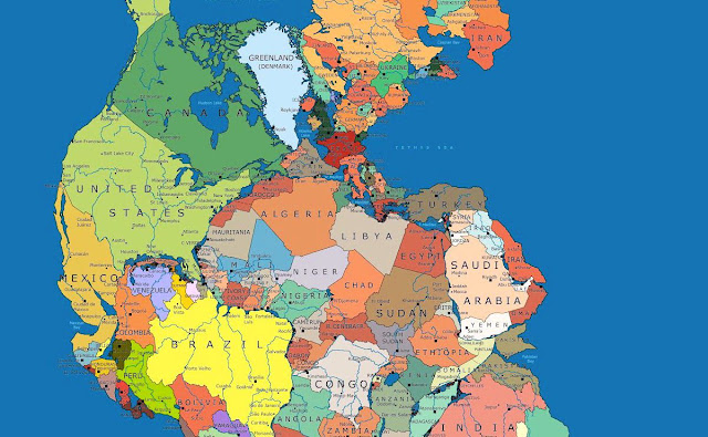
What Pangea would look like with our current international borders
 |
| Pangaea Politica By Massimo Pietrobon |
About 300 million years ago, Earth did not have seven continents (or eight if you count Zealandia), but one supercontinent called Pangea, which was surrounded by one ocean called Panthalassa. About 200 million years ago, the supercontinent began to break up and the world as we know it today started to take shape.
The map above is one of my all time favourites. It shows Pangaea, a supercontinent that existed from 300 million to 175 million years ago, with modern international borders.
Needless to say it would make international relations a little bit more complicated. Major changes include:
- The United States now borders a few new countries including Morocco, Mauritania, Senegal and Cuba.
- Spain now has a land border with Algeria.
- Italy now borders Tunisia.
- Greece borders Libya.
- Brazil borders a whole bunch of new states from Namibia in the south to Liberia in the north.
- India now finds itself in the southern hemisphere, right next to Antarctica.
- You could walk from Australia to Tibet (which is no longer attached to China).
- While China has lost Tibet it has gained a massive amount of new coast line.
Notice anything else that might complicate international politics? Then please, leave a comment in the comment section below.
To be able to zoom in on the map and see more details, click here.
—————————————–
References:
Matador Network
FineArtAmerica.com
Brilliant Maps